Map
Detailed Information
- Place Types Transit station
- Address New Orleans, LA 70128, USA
- Coordinate 30.070271,-89.950465
- Website Unknown
- Rating 5
- Compound Code 32CX+4R New Orleans, LA, USA
Photos
Reviews

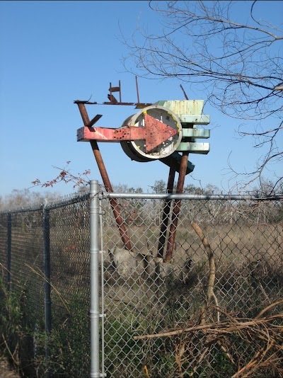
Piece of Black American History. This now decaying sign was once part of the beach and pointed toward what was the parking lot of the amusement park. Now the parking lot is the fields where the trees have overgrown it. A tunnel that went under the railroad led up to the beach from the parking lot. It can still be seen on old maps of the amusement park. The tunnel can also still be seen from Google Maps and Google Earth. It doesn't look safe to explore it though; I imagine crocodiles or alligators lurk in it. **Update: apparently the tunnels from the old parking lot have since been cleaned and cleared away, but Google Maps and Google Earth have not updated the images.nnAlso interesting to see that Haynes blvd is actually closer to the beach than it used to be. It used to be on the opposite side of the tracks behind the parking area. You can still see one of the old entrances to the parking lot if you go to the now residential block that is Curran Blvd which used to be Haynes Blvd before it was relocated across the tracks to where it is today. The entrance can be seen on Curran Blvd between Shorewood and Shamrock. Can even see some of the pavement there. Very interesting. I'm guessing that it was moved down for the real estate development. Hopefully the sign and parking lot will also be restored one day to its original glory. ❤❤
Similar place